Map It!
Students create maps to show the geographic features, regions, and economy of a state or region.
Task
A cartographer is someone who makes maps and charts to help people get information about a place. In this project, you will become an expert cartographer as you make maps that show geographic features, political features, and economic information for your state.
Engage
Collect a variety of maps you can share with students. You will want to have examples of political maps, physical maps, and maybe even topographic maps. Have students collect examples of maps they find in newspapers, magazines, and brochures.
As students collect and explore these maps, activate prior knowledge by having the class brainstorm some of the different things they find on the maps. Ask students to identify the compass rose, scale, and legend on the maps. Have the class brainstorm reasons why it is important to have these items on a map. How do they help us read and understand maps?
List the features found on a political, physical, or economic map. As a class, determine why each type of map is important. What information can you find on these different types of maps?
Then, have students sort the sample maps into groups of the same type. As a class, identify key features that make a map political, physical, topographical, or economic.
Let the students know that you will be asking them to apply their knowledge of maps as they show what they know about their state by creating a political, physical, and economic map for it.
Have the class brainstorm things they know about the state or region you are studying. Using chart paper, a white board, or sticky notes, put the words they brainstorm in a place where all students can see them. As a class, group ideas together into topics such as political, economic, geographic, historic, environmental, and entertainment. This will help them begin to think about the different types of information they can add to a map.
The Internet Public Library has a great section called Stately Knowledge with lots of factual information about each state.
Create
Have students use tools like Wixie or Pixie to create a political map. If you are studying only your state, have each student make a political map of their state. If you are studying the entire country, have each student create a political map of a different state. Students can use the Text tool to identify important cities and places and the Paint tools to add more specific details.
Next, have students create a physical map of their state. They can use Pixie’s Paint tools to show the geographic regions in their state. They can use Pixie’s Map Icon stickers to show prominent geographic features.
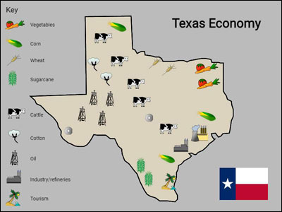
If you are learning about economics, you will study industrial and agri-cultural production in your state. Have students use Pixie’s Map Icons stickers to identify where in your state products are produced and services are rendered.
Make sure students print a copy of each of their maps.
Share
Hang the printed maps in groups by type so everyone can see them. Have the students identify similarities and differences between the maps. Have them identify new information that they learned from other students’ maps.
Assessment
You can assess for prior factual knowledge as you have the class brainstorm information about your state. As students explore and sort the different map examples you share, you will be able to assess their understanding of the different types of maps and what information they convey. Their ideas on how the compass rose, scale, and legend help us read and understand maps will also help you assess their understanding before they begin creating their maps.
You will be able to specifically assess their factual knowledge about your state through their research. Their political, physical, and economic maps will also allow you to assess both map making skills and factual knowledge about the state.
Resources
Atlapedia Physical and Political World Maps
Color Landform Atlas of the US
Standards
NCSS- National Council for Social Studies
III. People, Places & Environments
c. use appropriate resources, data sources, and geographic tools such as maps to generate, manipulate, and interpret information.
National Geography Standards
The World in Spatial Terms
The geographically informed person knows and understands:
1. How to use maps and other geographic representations, tools, and technologies to acquire, process, and report information from a spatial perspective
3. How to analyze the spatial organization of people, places and environments on the Earth’s surface
Places and Regions
The geographically informed person knows and understands:
4. The physical and human characteristics of places
6. Creative Communicator
Students communicate clearly and express themselves creatively for a variety of purposes using the platforms, tools, styles, formats and digital media appropriate to their goals. Students:
a. choose the appropriate platforms and tools for meeting the desired objectives of their creation or communication.
b. create original works or responsibly repurpose or remix digital resources into new creations.
c. contribute constructively to project teams, assuming various roles and responsibilities to work effectively toward a common goal.
d. publish or present content that customizes the message and medium for their intended audiences.


